Learn about the geographical division of Puerto Rico
While writing about Puerto Rico, I realised that may be not everyone is familiar to the geographical division of puerto rico, a small but beautiful island. So, I decided to write a short article about the different regions and the departments that belong to each one in particular.
Puerto Rico is an island in which you can find all kinds of different landscapes, from beautiful white sand beaches with crystal clear water (because it is surrounded by the Atlantic Ocean and Caribbean Sea) to green jungle mountains. As a consequence, there a lot of different activities you can enjoy if you decide to come to Puerto Rico (I wrote about this in another blog). Added to this, people in Puerto Rico are excellent hosts, so proud of their land and accomplishments, and so eager to entertain tourist. So let’s take a look to the different departments of Puerto Rico!


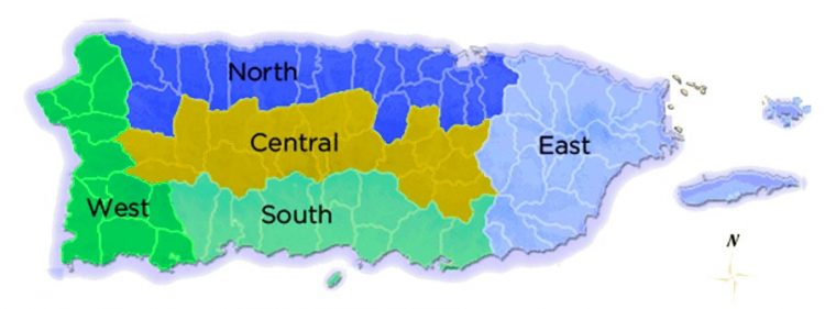
North Region – Porta Atlantico
Land of caves and rivers and coast. Here there are the most impressive attractions of the Island: Camuy Caves and the Arecibo Telescope. This region has a lot to offer, such as, archaeological and historical exhibitions, blow minded beaches and intensive forests. This is the list of towns that belong to Porta Atlantico: Arecibo, Barceloneta, Bayamon, Camuy, Catano, Corozal, Dorado, Florida, Guaynabo, Hatillo, Isabela, Manati, Morovis, Quebradillas, Rio Piedras, San Sebastian, San Juan, Toa Alta, Toa Baja, Vega Alta, Vega Baja.

Old San Juan, Puerto Rico.

This is the biggest mountainous area of Puerto Rico and it almost divides the Island in halves. It is characterized by the Cordillera Central which rises to heights between 3500 and 4400 feet above sea level. The cool climate through out the year and the rainfall in this region have made this area an important agricultural center. The Porta Cordillera includes: Adjuntas, Aguas Buenas, Aibonito, Barranquitas, Cavey, Ciales, Cidra, Comerio, Jayuya, Las Marias, Lares, Maricao, Naranjito, Orocovis, Utuado.


South Region – Porta Caribe
This region is a collection of coastal cities, quiet beaches, and colonial communities. It is the ideal place to enjoy outdoor activities. Its temperature is warm, and it is the driest area of the island. Porta Caribe includes: Coamo, Guayana, Guayanilla, Juana Diaz, Penuelas, Ponce, Salinas, Santa Isabel, Villalba, Yauco.


East Region – Porta Antillas
Porta Antillas has the three most important treasures of the island: The Yunque Forest, and the incredible islands of Vieques and Culebra. Also, Puerto Mosquito Bay is a place you must visit to see the impressive bioluminescent phenomena. This region includes: Arroyo, Caguas, Canovanas, Carolina, Ceiba, Culebra, Fajardo, Gurabo, Humacao, Juncos, Las Piedras, Loiza, Luquillo, Maunabo, Naguado, Patillas, Rio Grande, San Lorenzo, Trujillo Alto, Yabucao, Vieques.


West Region – Porta del Sol
Known as Puerto Rico’s surfing mecca. It goes from Isabela on the northwest coast to Guanica in the south. It is very popular because of its endless coastlines and most of the best beaches are located in Puerta del Sol. This is the place to dive and surf! Porta del sol covers: Aguada, Aguadilla, Anasco, San German, Cabo Rojo, Guanica, Hormigueros, Lajas, Mayaguez, Moca, Isla de Mona, Rincon, Sabana Grande.


By now, I hope that this article help you have a better and clear idea of Puerto Rico’s map and its regions and towns and the different activities that you can do in each one of them. Also, I hope it helps you decide your next destination according your preferences. As you can see, Puerto Rico is a small island, but there are a lot of different things to do and places to know. See you next time but do not forget to check out our webpage or follow us on facebook! Chau!
0 Comment